 What is mapping on a fish finder is directly proportional to how effective and time-conscious fishing attempt you wish for.
The mapping shows you exactly what is around and beneath the water, and when it comes to finding out what really is beneath the water, you need the sophisticated and trusted mapping system integrated into the fish finder.
Do not forget the built-in mapping system is clearly enough for the various kinds of fishing on the lakes and seashore but you cannot give your whole to it.
The reason for not giving wholly to it is super simple — not all the water resources are mapped out by the standard built-in map that your fishfinder holds.
Just like you cannot steer on the road without Google Maps, the mapping used on the fishfinder ensures not just your safety but makes your fishing trip even more successful. That is why we had mapped out earlier; it gives you a good hunch about what is around and beneath you!
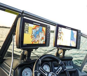
What is Mapping on a Fish Finder
Just like you take a good while judging it the water is worth going into and start exploring the bank by slowly sliding your feet to ensure its depth even though the folks around you tell exactly how deep the shore of the lake, river, or the ocean.
But that is all for leisure purposes, know swimming and then you do not have to beat yourself up much.
Fishing is the totally opposite scenario. And the different species of fish are found in different kinds of water structures and depths.
You cannot immediately judge what could be beneath your boat. Unlike the paved roads and highways where heightened extensions rarely come, underwater life is absolutely unpredictable.
So, then comes the maps to your rescue which you can profoundly use anywhere, on the different waters.
That is okay to cast anywhere you want but what good it would be when we know exactly where the fish would (most probably) hide due to their favorite structure down the water and we head straight to that? Wouldn’t that be cool enough, nope?
Yeah! That is exactly what the mapping on fish finders would use — providing the detail covering the depth, flats, riverbanks, surface types, and the list does not stop.
Do the Built-in Maps Work Good?
Well, that depends. Which lake or seashore you are going fishing in and it is already upon your fishfinder, then you are in pure luck.
Maybe you are bound to spend time in the Southern U.S.A. and find almost all the lakes and such shown on the fish finder with good enough details. But if you plan to go fishing in the Western U.S.A., maybe that part would not be covered.
So, always check with your fish finder brand as to whether they include the built-in maps and to which region.
And the international spots would definitely go missing. So, bear in mind you must confirm with your brand about its map support.
What Top Fish Finders Brand Support in Map
Let’s take a sneak peek at the maps the few top fishfinder brands support!
Garmin Fish Finders Supporting Maps
Apart from the stock and built-in maps, you can update or purchase the maps for your Garmin fish finders.
But before doing that, make sure your Garmin supports either Navionics+ or Navionics Vision+ for the updates and purchase to work.
Also, most of the maps come in the form of a microSD card, so just a note to check out if yours does support the card thing as well.
- Up to I’ Contours
- Auto Guidance Technology
- ActiveCaptain Community
- Depth Range Shading
- Shallow Water Shading
- Raster Cartography
- High-resolution Relief Shading
- High-Resolution Satellite Imagery
- Sonar Imagery
- Aerial Photography
- Side Scan Images
- 3D FishEye View
- 3D Marine View
- Dynamic Lake Level
Humminbird’s Supporting Mapping Technology
The following maps are the ones that Humminbird supports with its different fish finder variants;
- BaseMap
- AutoChart Live
- LakeMaster
- SmartStrike
- ChartSelect
- CoastMaster
- Navionics
Lowrance Fish Finders Supporting Map
Lowrance got these maps to its different fish finders…
Lowrance C-MAP REVEAL™-Supported Fish Finders
- Shaded Relief
- Full-Featured Vector Charts
- Hi-Res Bathymetry Layer
- Custom Depth Shading
- Satellite Overlay
- Aerial Photos
- Dynamic Raster Charts
- Easy Routing
- Tides and Currents
- Detailed Marina Port Plans
Lowrance C-MAP Discover™-Supported Fish Finders
-
- Full-Featured Vector Charts
- Hi-Res Bathymeter Layer
- Custom Depth Shading
- Easy Routing
- Tides & Currents
- Detailed Marina Ports Plans
Conclusion!
The beauty of having the best technology in hand does not mean enjoying fishing the most! Especially when your target is to reach the right spot and hook and catch the fish unstoppably.
Although, what is mapping on a fish finder that comes as stock does the job quite effectively but the thing is, which map you should go with. The stock one will definitely stop working at a certain level.
So, let’s not waste the time casting the line and waiting for the hook to be caught. Go with the right fish finder allowing you to hook/update/download your favorite fishing map.
Learn it the best and see your fishing experience dwelling!
- What Do You Need for Fishing - August 18, 2022
- How to Find Offshore Fishing Spots - August 18, 2022
- What to Use for Trout Fishing - August 17, 2022