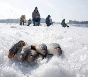
 Ice fishing can be a tedious task if you do not know the secrets and the hacks because choosing the wrong point can cause you to be stuck with hours of struggle. But you can also have the advantage of easy fishing without using a boat or any fancy accessories and can do a lot of fishing at the same spot
.There are various ways to mark the waypoints when ice fishing for later use. You can either use the current location or the GPS coordinates to keep them. Fishfinders have extensive use in ice fishing, and you can also use them to mark the waypoint on your favorite sites.
Marking the waypoints is good, and there are many ways by which you can do it.In this article, we will discuss how to mark and use the waypoint on a fish finder in ice fishing.
GPS Coordinates Way Point
You can use the specified GPS coordinates of the sweet spots in the lake or river marked favorites by the anglers. These coordinates are available on various platforms and are generally based on the wrecks, buoys, hazards, and structures where the maximum tendency to find the fish is. Entering the correct number and double-checking them is essential because each number can alter the location by many miles. These are the steps to enter the waypoint on fishfinder using the GPS coordinates:
- Press the menu button
- Select waypoints from the list.
- Select new waypoint
- Select enter coordinates option
- Enter the designated coordinates carefully and double-check them
- Press the enter button and enter more information that you think would be helpful.
- There are options of name, symbol, depth, water temperature, and comment in most fish finders.
Map Waypoint
This is a relatively easy way to enter the waypoint and you can do it quickly to make any location on the map. All you need is to follow these steps:
- Go to the menu and select a waypoint from the list.
- Select a new waypoint like before
- From the options, choose the waypoint map
- It will display the map, and you can mark the desired location on the map with the navigational tool.
- When you press enter, it will display more information about the waypoint that you can add.
Current Location
You can easily mark the waypoint on the current location if you are doing good fishing and have discovered a structure or a reef with more fish. Just press the marked waypoint, and it will do that.
How To use Waypoint Of Fish Finder In Ice Fishing
Fishfinders have the same value in ice fishing as in the traditional fishery, and they can be used not only for navigation but for a quick check of the ice hole. There are a lot of community ice holes in the winter season that are marked as productive by other anglers, and you can get the data and feed it into your fishfinder. Once you have provided all the waypoints in your fish finder, you can go to the nearest waypoint and grab your things. It is better to use the fish finder first to realize that something is beneath the surface.
There is also the depth feature in the waypoint, and you can also feed the recommended depth where the fishing chances are maximum. There is also the comment option in the waypoint by which you can add information such as the time of the day when you caught the fish or the last time you visited that spot. You can also add the fish type you saw there and the quantity.
Conclusion
The waypoint feature has extensive use in fishing, especially in ice fishing, because it lets the anglers fish without the need to dig a new hole, and they can feed the best fishing spot in their fish finders. Moreover, the fish finder option also has the feature where you can add the waypoint based on the experience of other anglers; it also gives various other options such as marking the depth and water temperature.
- What Do You Need for Fishing - August 18, 2022
- How to Find Offshore Fishing Spots - August 18, 2022
- What to Use for Trout Fishing - August 17, 2022